C360 Ontario
architectural
Services
Welcome to C360 Ontario
At C360 Ontario, we elevate spaces with precision 3D modelling and 2D solutions. Serving Whitby, Ajax, Pickering, Toronto, Oshawa, and beyond, our services include 3D modeling, 3D tours, 3D renderings, architectural drawings, on-site scanning, and the creation of AutoCAD, Revit, DWG, E57, LAS, LAZ, PLY, RCP, OBJ, LCC, MESH, and PDF files. Utilizing Matterport and XGrids technology, we deliver unparalleled visualization, accuracy, and 3D interactive experiences for both commercial and residential projects and spaces. Whether you're an architect, designer, property owner, realtor, estimator, or business owner, or part of an architectural or drafting firm, explore the exciting future of spatial visualization today.
Our Services At C360 Ontario
2D & Custom Floor Plans
3D Furnished / Staged Floor Plans
3D Rendered Walkthroughs
Professional Photography
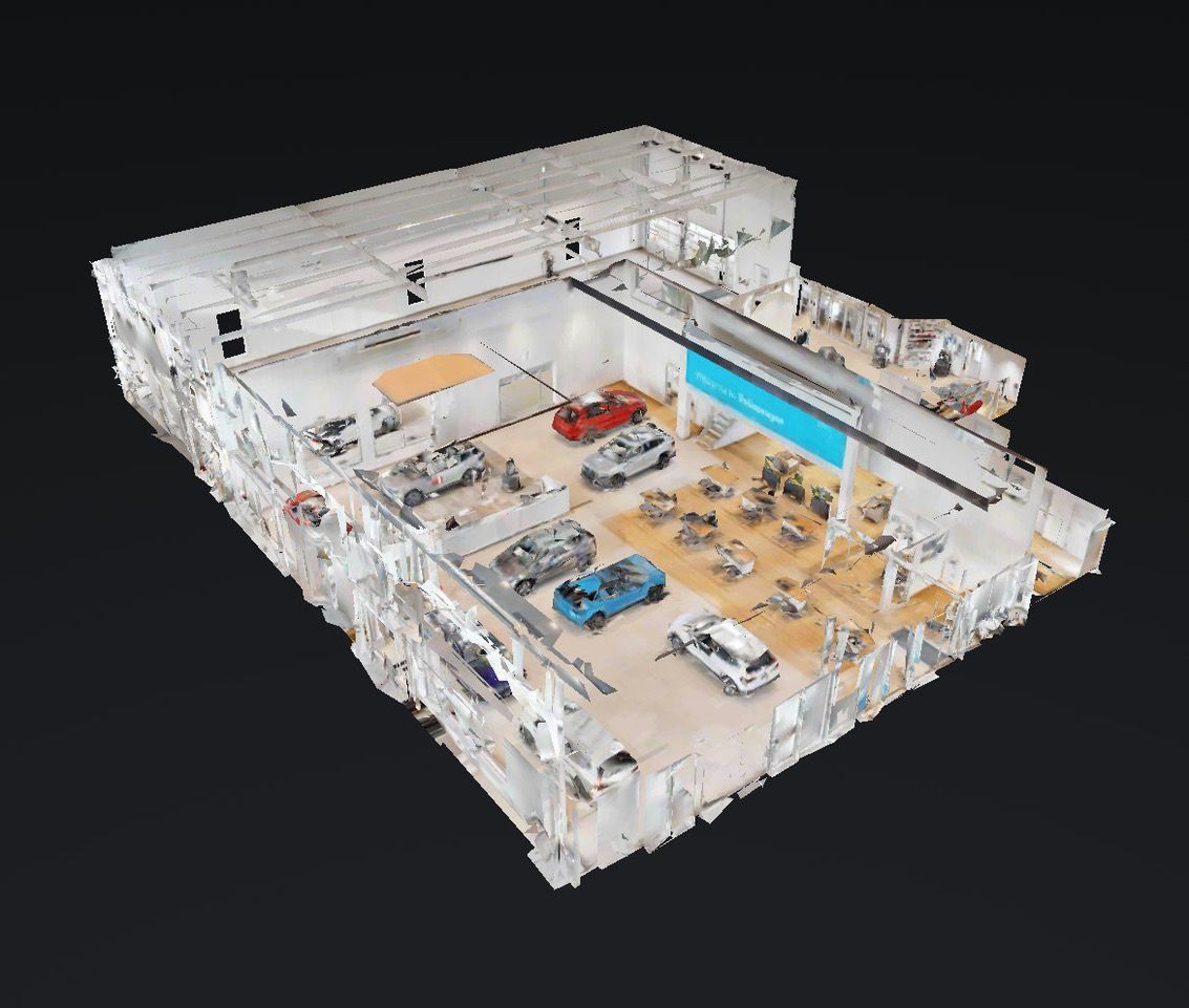
Immersive 3D Tours & Virtual Models
XGrids & Matterport 3D Scanning
On-Site Measurements & Infrared Scanning
3D Scanning Into BIM
As-Built Drawings
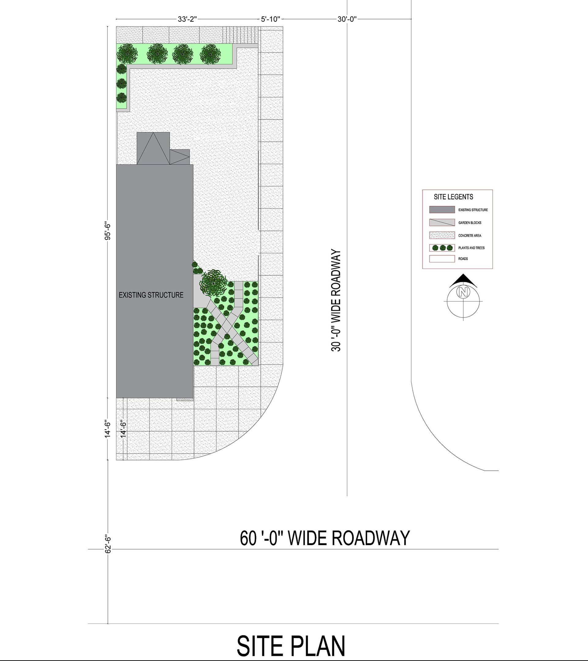
Comprehensive Architectural Drawings: Sections, Elevations, Custom Floorplans, Site Plans, Detailed Kitchen & Bathroom Drawings & More
Drone Photography & Videography
AutoCAD, Revit, DWG, E57, LAS, LAZ, RCP, OBJ, LCC, MESH & PLY File Creation
Affordable Real Estate Listing Presentation Pages & Virtual Showings
Construction Documentation
C360 Ontario & Architectural Innovation
C360 Ontario is your trusted source for architectural excellence and innovation. Specializing in 3D modeling and 2D solutions, we transform and recreate commercial and residential spaces with precision. Proudly Canadian-owned and based in the Durham Region, we serve Whitby, Ajax, Pickering, Toronto, Oshawa, and beyond.
Our skilled team delivers high-accuracy services, including 3D modeling, 3D tours, 3D renderings, and detailed architectural drawings. We offer on-site scanning enhanced with infrared technology and provide comprehensive documentation with AutoCAD, Revit, E57, DWG and PDF files, alongside our XGrids point cloud data in LAS, LAZ, PLY, RCP, E57, OBJ, LCC and MESH formats. Clients, including realtors, estimators, and firms, can access these files to facilitate the ongoing design, development, or management of architectural projects efficiently and effectively. Our expertise in Matterport and XGrids technology ensures immersive 3D interactive experiences that enhance collaborative communication and decision-making.
Committed to quality and affordability, C360 Ontario offers solutions that streamline processes, minimize errors, and keep your projects on track. Discover the future of spatial visualization with our "Reality Capture" and drawing services. Contact us today to learn more.
Understanding “Reality Capture”
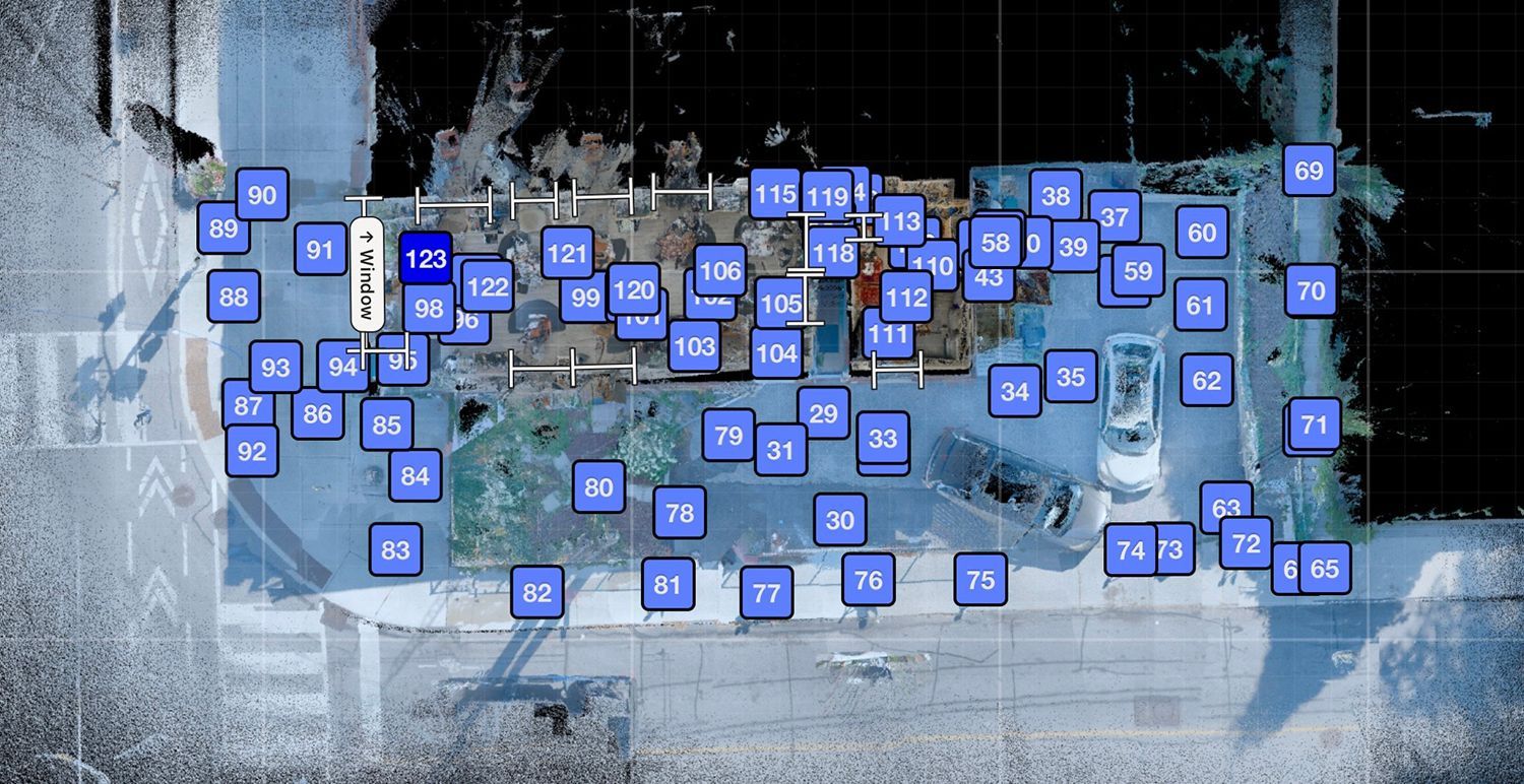
“Reality Capture” utilizes 3D scanners, drones, and photogrammetry to gather precise data from real-world environments. This technology allows us to create detailed digital models essential for architectural planning and design. Known for our expertise in XGrids and Matterport 3D scanning, we've got your scanning needs covered.
How Is “Reality Capture” Useful?
“Reality Capture” is a process that involves capturing and processing data from the physical world to create a digital representation or model. This technology is useful in various industries for a wide range of applications. Some of the key benefits of “Reality Capture” include:
Precision
Delivers accurate architectural documentation with exact measurements.
Efficiency
Streamlines the design processes, reducing the need for multiple site visits.
Cost-Effectiveness
Minimizes errors and project delays to save time and money.
Documentation
Maintains comprehensive digital records for renovations and future projects
Visualization & Access
Improves communication among professionals with detailed models and virtual walkthroughs—explore spaces without physical presence.
Enhance your commercial and residential architectural projects and spaces with our state-of-the-art “Reality Capture” and drawing services. Contact us today to learn more.
Explore XGrids Laser Scanning With SLAM
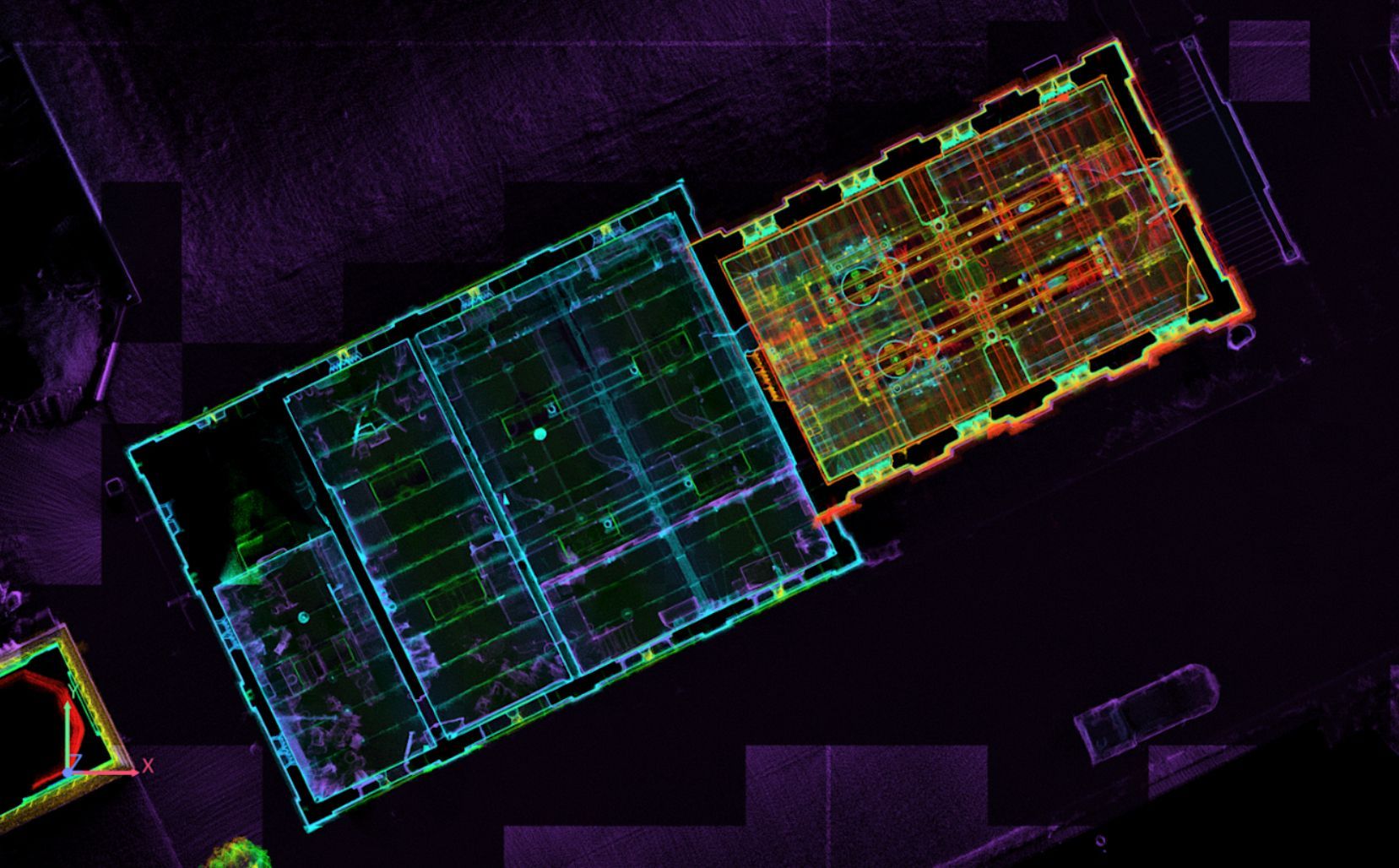
Transform your architectural projects with XGrids Laser Scanning, powered by advanced SLAM (Simultaneous Localization and Mapping) technology. SLAM enables real-time environment mapping and precise location tracking of the scanner, allowing for the creation of detailed models in complex spaces. Capture dense point clouds with accuracy, essential for high-quality models in AutoCAD and Revit.
Effortlessly export your projects in various formats, including E57, LAS, LAZ, PLY, RCP, OBJ, LCC, and MESH.
Discover the future of design innovation with XGrids Laser Scanning. Learn more about our laser scanning services on our Services page.
Slide title
Write your caption hereButton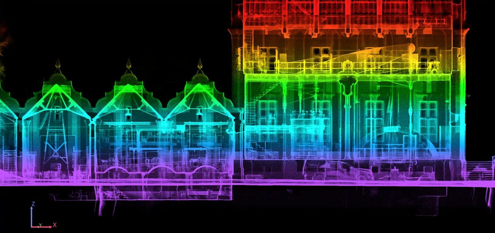
Slide title
Write your caption hereButton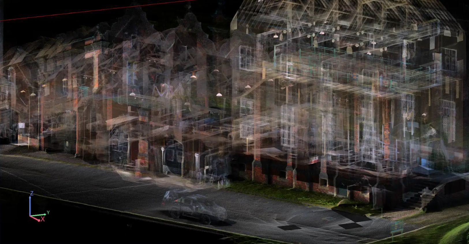
Slide title
Write your caption hereButton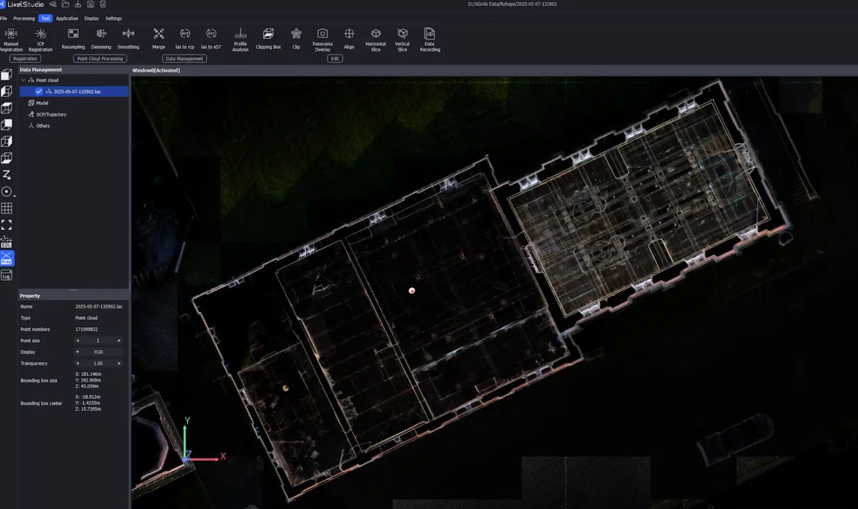
Slide title
Write your caption hereButton
What Are Our Technology Tools?
We use XGrids and Matterport software both designed to bring speed, scale and simplicity to your digital reality projects. Thanks to our newly updated virtual project interface and step by step guided interface, we can use measurement tools from Lixel LCC Viewer or Matterport, to document your sites or property from virtually anywhere in the world with stunning detail and precision.
Our Process
Step 1
Hello Phase
Contact us
Let us know your specific needs and goals. We can provide complementary initial consultations!
Estimate Preparation
We can provide you with a detailed written estimate of our competitive pricing or simply provide a telephone estimate with of our quotes based on the scope, complexity and technical requirements of your project.
Information Exchange
Provide us with your information/documents including the scope of the work required as well as deadline considerations.
Step 2
Capturing & Editing Phase
On-site Scan
Using a highly skilled C360 Ontario technician we complete a virtual information scan.
Data Collection
The digital information captured on-site is collected and imported using our sophisticated tools/cameras and sent to our offices.
Step 3
Processing & Delivery Phase
Analyzing & Processing
The digital information collected on-site is analyzed and processed at our office using the best and most appropriate software tools to ensure 100% client satisfaction.
Delivery
We deliver our final product to you (approximately 3-7 days after scanning). File formats include DWG, PDF, E57, RCP, LAS, LAZ, PLY, MESH, OBJ, LCC, Revit, AutoCAD, Lixel LLC Viewer, Matterport URL link, or downloadable content, depending on client needs and requirements.
File Enhancement
We smooth out technical imperfections and enhance digital images to enhance our visual imagery to ensure we enhance our product for our customers with a visually appealing and professional product. We guarantee our results!
C360 Ontario FAQ
Who can benefit from our services?
Our services appeal to a wide variety of customers and industries. From large to small jobs, we serve Realtors, Builders, Insurance Brokers, Homeowners, Hobbyists, Project Managers, etc. We at C360 Ontario want to make your project a success by ensuring accurate and appealing visual images to meet your needs and exceed your expectations. We pride ourselves on our local knowledge across the Greater Toronto Area.
How long is the turnaround time for most projects?
Once we scope out your goals and requirements, we will ensure we meet your project schedule and deadlines. As a guideline, an average size building (approx 3000 sq ft) can be mapped and delivered to you in about 2 to 5 days. We pride ourselves on working closely with our clients to deliver quick turn around times while ensuring top quality results are achieved. We have a keen eye for ensuring every photo and virtual model will meet and exceed expectations.
Can we use the Matterport technology outside in various weather conditions?
C360 Ontario uses technicians that are highly trained in the use of Matterport technology and, under acceptable weather conditions we can use the technology in outdoor applications. That said, usually Matterport is usually utilized in indoor conditions. Our expert technicians work closely with our clients to ensure our technology and approach is just what you need.
Is there any Client preparation needed before a scan or photo shoot of a property/site?
Yes. For best results, there are few things that we need you complete before we arrive on site or to your buildings’ location. Some basic preparations include clearing away debris or obstructions on the property to ensure we have a clear view of all building structures and to ensure cleared walking paths for our technicians. These simple but effective steps will help our technicians achieve their best work. Please check with us to go over site preparation details/requirements to ensure best results.
What equipment is used?
Ground Level Reality Capture - Creation Xgrids Lixel L2 Pro with Lixel Studio plus Lixel LLC Color Software for clients, or Matterport Pro 3 with Matterport software.
Cameras - Sony A7 & Sony Alpha 1 Camera with multiple use lenses. Note: Optional and additional photo shop editing services are available upon request and quoted separately.
Drone - DJI Mavic Air 2
WHAT GEOGRAPHIC AREA DOES C360 ONTARIO OFFER SERVICES TO?
At C360 Ontario we service the Greater Toronto Area (GTA) but specialize in Durham Region. For larger projects outside of the GTA, we may be able to help. Please contact us for further information with regard to your specific needs and location.
HOW LONG DOES A “REALITY CAPTURE” SCAN TAKE?
Depending on the size of the project, timing can vary. A Matterport model usually takes about 2 - 6 hours on-site to capture the data itself. From there, editing of the scans can take additional time depending on the depth and scope of the project application.
Can the scans be used in BIM software?
Yes. We currently offer scan to BIM services to help drafters, engineers and Architects complete their job faster and more accurately than ever before!
What is the difference between Matterport floor plans and normal blueprint floor plans?
Standard blueprints and floor plans are awkward and limited in their use. Standard floor plans do not capture key details and measurements associated with a variety of building structures such as windows, doors, bathtubs, showers, sinks, cabinets ,counters, walls, appliances etc. Using Matterport models allows the client to view everything in stunning detail and accuracy. Never before have we had the ability to literally bring your projects to life with the use of this state of the art technology. This new technology will literally transform how we utilize information in 3D format.
HOW ACCURATE IS THE MEASUREMENT TOOL IN LIXEL LLC VIEWER SOFTWARE?
Unparalleled precision is the hallmark of "Reality Capture" services, as our tools provide an impressive 99.8% accuracy to the actual scale of the subject matter. Regardless of your needs, these services simplify the task of documenting or measuring architectural components or site conditions directly from your office, home computer, or laptop.